Traveling across southern Alberta on a dusty back road, I suddenly became conscious of a ditch at the side of the road, filled with water. There are many ditches that had pools of water in them but this water was different. Out in the open prairie, away from any water source, this ditch was full and the water seemed to be moving. I came to a cross roads, got out of the car and walked over to the ditch. The water was indeed flowing and clear. There were few weeds growing in it and across it lay a small walking bridge with a turn wheel on one end. Looking across the road I saw the ditch of sparkling blue water running straight and true off into the horizon. I was surprised by the water. Intrigued, I followed it.
A sign popped up on the long, straight road I had been traveling on. It read “Brooks Aqueduct”. I turned from the town of Brooks and followed a dirt road to one of the biggest surprises I had on my trip through Southern Alberta: The Brooks Aqueduct.
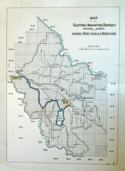
This map shows the canals and reservoirs of the Eastern Irrigation District. Amazing to see how much water there is!
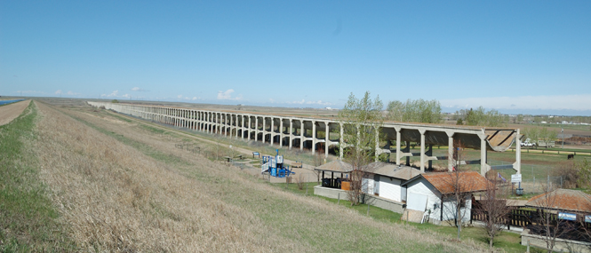
Looming up out of the prairie stands a giant sculpture, spanning far out into the wild grasses, both to the left and right of the road. A hill rises between the two pieces, almost as if it had been cut to accommodate the road. At the top of the hill I stopped and got out of the car. A semi circle trough stands about 20 meters off the ground and is a massive structure. Information boards before me explained that the troughs were called flumes and they are 6.9 meters wide and is 2.6 meters deep. Constructed from 1912 to 1914 by the Canadian Pacific Railway Company, the Brooks Aqueduct operated from 1914 to 1979 and was a crucial link in the CPR’s irrigation network through the Eastern Irrigation Section. During that time it carried water to farmlands in the north and east of Alberta, previously barren land. In 1979 a larger irrigation canal was completed and the aqueduct was abandoned.
At the information booth, two local students are there to answer questions and tell you the story of the aqueduct and canal systems, a truly fascinating tale . Visitors can drive or walk the 4.2 km Roadside Trail which follows the length of the aqueduct on one side. A trail guide can be obtained from the information booth which will allow you to stop at numbered spots on the trail and read more about the Aqueduct, the people who built it and how they repaired it.
Midway a gravel path leads you off the trail and through marshland first to a covered bench and then onward to an open area with picnic tables by the water. A variety of animals call it home and the bird songs that rise from the marshland are mesmerizing.
I’ve only given you a brief introduction to the Brooks Aqueduct. It’s rich history and astounding size is something you need to experience for yourself. With a fantastic nature walk and picnic spot on site and with spectacular camping like Tillebrook Provincial Park nearby I hope more people go off the beaten path and visit this National and Provincial Historic Site.
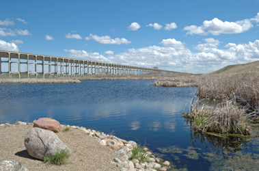
This view of the marshlands and aqueduct is the perfect spot for a picnic.